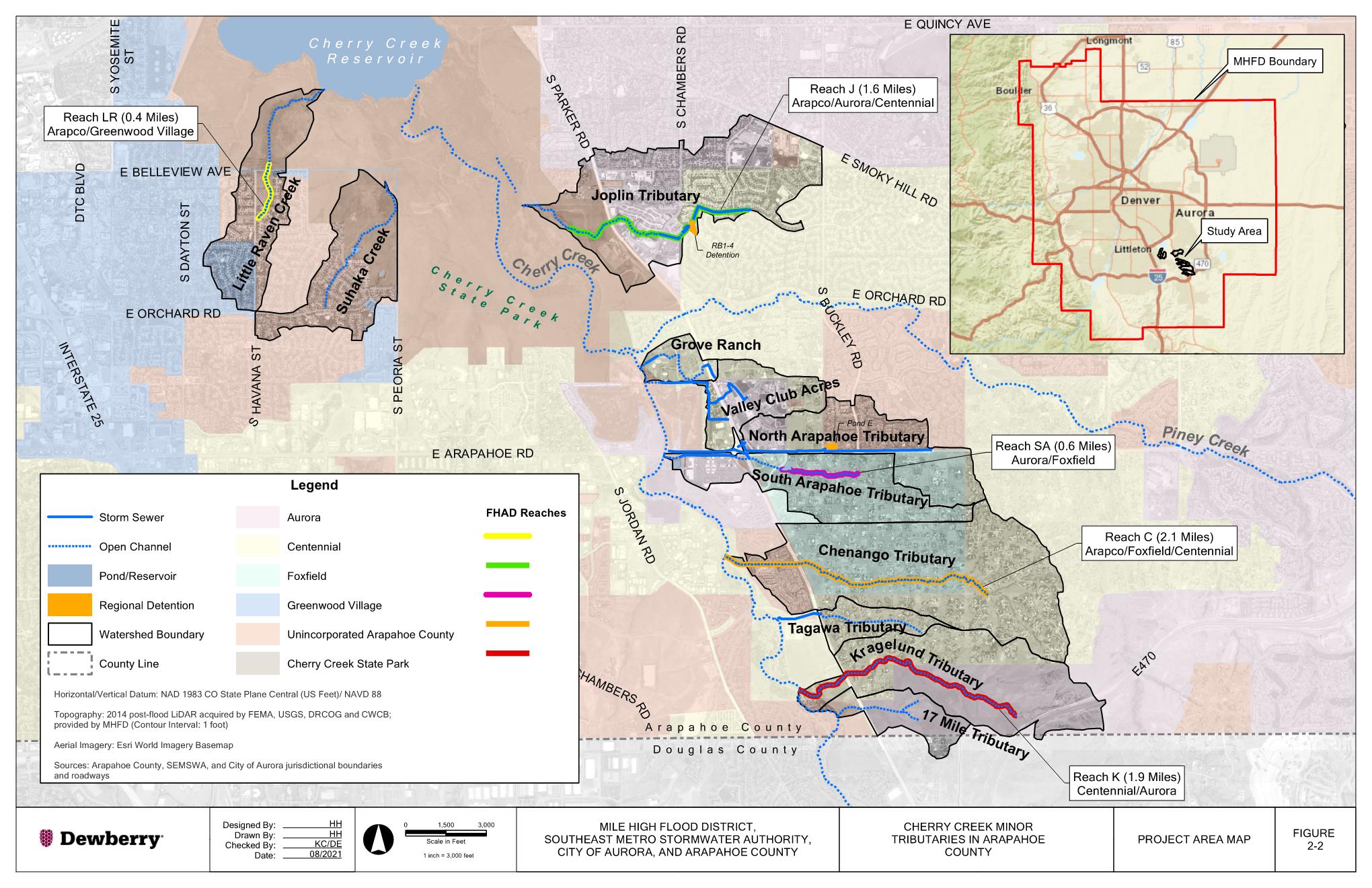
Dewberry is contracted to complete a Major Drainageway Planning (MDP) study and Flood Hazard Area Delineation (FHAD) study for the previously unstudied tributaries to Cherry Creek. Mile High Flood District (MHFD) engaged Dewberry to conduct this study, which incorporates the following sponsors: City of Aurora, Arapahoe County, and Southeast Metro Stormwater Authority (SEMSWA). The project is studying eleven (11) tributary basins, including Little Raven Creek (previously North Unnamed), Suhaka Creek, Joplin Tributary, Grove Ranch Tributary, Valley Club Acres Tributary, North Arapahoe Tributary, South Arapahoe Tributary, Chenango Tributary, Kragelund Tributary (previously South Unnamed), and 17 Mile Tributary.
The purpose of this study is to analyze the existing and future floodplain delineation, assess stream functionality, and develop a set of alternatives and plans that will maintain the ecological health of the reach and address existing and future flooding and erosion concerns. The drainage basin is almost fully developed except for Cherry Creek State Park and the proposed King’s Point development northeast of E-470 and Parker Rd. Except for Cherry Creek State Park, existing land uses largely consist of residential and commercial areas.
The four phases of the MDP study are to 1) assess baseline hydrology, 2) create a FHAD, 3) conduct an alternatives analysis, and 4) formulate a conceptual design. Project goals include:
· Update hydrology in the basin,
· Identify existing flooding and drainage issues,
· Obtain and consider input from the public, stakeholders, and sponsors for feasible alternatives,
· Recommend conceptual stormwater conveyance, high functioning and low maintenance stream corridors, and detention improvement measures.
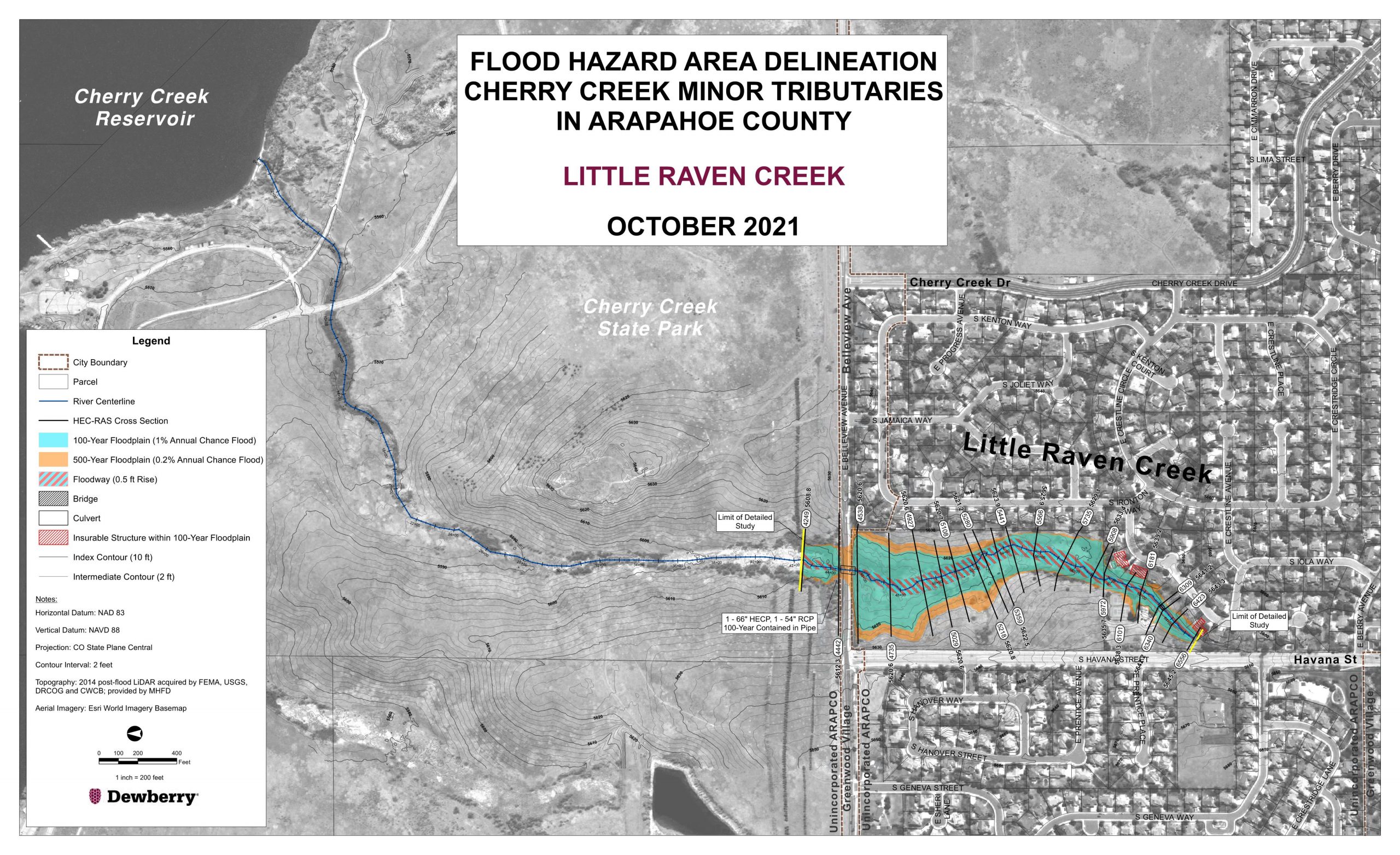
Little Raven Creek, previously referred to as North Unnamed Tributary, coveys runoff from an approximately 349-acre basin and is 7,700 feet in length. This tributary basin includes about 93 acres in the City of Greenwood Village and 256 acres in unincorporated Arapahoe County, 133 acres of which is served by SEMSWA. The area not served by SEMSWA is owned by Cherry Creek State Park. The area is fully built out and there are no vacant properties for future development within the basin.
FHAD
Little Raven Creek is included in the FHAD. Due to the build-out nature of this basin, future land use hydrology was used for the FHAD and is considered equal to existing for Little Raven Creek. There are three residential homes identified as being in the upper portion of the Little Raven Creek 100-year floodplain. The upstream portion of the channel also appears to have erosional issues and there are no water quality features on Little Raven Creek. The alternatives analyzed for this tributary are as follows.
Alternatives
Alternative 1 and 2 were evaluated for improvements in the basin.
If you have comments on the recommended alternatives please email Katie Kerstiens: kkerstiens@mhfd.org.
Status Quo
Since there are three homes identified in the 100-year floodplain, the Status Quo alternative was not evaluated as substantial damage is anticipated to result from doing nothing in this reach.
Alternative 1 – Floodplain Preservation, Mitigation and Management
To preserve the existing Little Raven Creek floodplain in the reach of interest, a permanent drainage easement 11 acres in size is required to contain the 100-year floodplain. Additionally, the three homes identified as being inundated by the 100-year floodplain are required to be purchased and demolished and one trail crossing culvert would need to be repaired.
Alternative 2 – Conveyance Improvements
To reduce flood risk and address erosional and water quality concerns through the Little Raven Creek study reach, conveyance improvements are required. The proposed improvements include a high functioning low maintenance process channel. The proposed channel has a stable longitudinal slope of 1.1%, 1.5 ft of freeboard in the channel between the 100-year water surface elevation and the surrounding terrain, the two three-foot drop structures that are required to maintain the slope. Alternative 2 for Little Raven Creek includes a 10-ft maintenance trail, which may double as a recreational trail.
Considerations
The potential water quality pond location, drainage area, and water quality capture volume (WQCV) were analyzed in the CCBWQA study. The proposed online pond location is just upstream of E. Belleview Ave. along Little Raven Creek. The drainage area for this pond is 208 acres. The WQCV was calculated to be 3.61 ac-ft with a drain time of 40 hours. The conceptual design of the pond has 3.76 ac-ft volume and is 5 ft deep. The bottom slope of the pond is roughly 1%.
Recommended Alternative
To reduce flood risk and address erosional and water quality concerns through the Little Raven Creek study reach, Alternative 2 (open channel conveyance improvements) and the addition of a water quality pond is recommended.
The improved channel will increase public safety by removing three insurable structures from the floodplain. Additionally, the recommended high function low maintenance process channel will increase the environmental function of the reach by providing a more natural stream environment and reconnecting the channel to its natural plan and form. Furthermore, a recreational/maintenance trail along the channel corridor and replacement of park programming in the overbank region will benefit the surrounding community.
The water quality pond recommended by the CCBWQA will improve the water quality of flow conveyed downstream into Cherry Creek.
Suhaka Creek, previously referred to as Tributary to Cottonwood Creek, conveys runoff from approximately 360 acres of single-family development with open space at the downstream reaches. Most of the watershed lies in unincorporated Arapahoe County with a small 9-acre area located in Greenwood Village near Lake Ct. Approximately 193 acres of this area is served by SEMSWA and the area not served by SEMSWA is owned by Cherry Creek State Park.
FHAD
Suhaka Creek is not included in the FHAD since there is little to no open channel. Due to the built-out nature of this basin, future land us hydrology is considered equal to existing for Suhaka Creek.
Alternatives
A potential capacity issue at the culverts that convey Suhaka Creek beneath Cherry Creek Drive – a minor collector in Unincorporated Arapahoe County – was identified. The culverts at S. Peoria Street are considerably smaller than the culverts upstream at Cherry Creek Drive, so there is a potential for overtopping at this crossing. However, S. Peoria Street is located within Cherry Creek State Park and was therefore outside the limits of this study. The alternatives analyzed for this tributary are as follows.
Status Quo
During the 100-year event the maximum outlet velocity for the existing culvert at Cherry Creek Drive is approximately 16 ft/s, which presents a threat to public safety associated with anticipated roadway and channel damage caused by the jet coming out of the culverts. Therefore, the Status Quo alternative was note evaluated as substantial damage is anticipated to result from doing nothing in this reach.
Alternative 1 – Floodplain Preservation, Mitigation and Management
The floodplain preservation, mitigation and management alternative was not evaluated for Suhaka Creek because the area of concern was limited to the Cherry Creek Drive crossing – no adverse impact to surrounding homes was identified.
Alternative 2 – Conveyance Improvements
To address public safety concerns at the Cherry Creek Drive crossing, conveyance capacity and erosion mitigation improvements are required. The proposed conveyance improvements include upsizing the existing culvert at Cherry Creek Drive slightly from dual 60” RCPs to dual 66” RCPs. Additionally, structural energy dissipation is required downstream of the improved culverts to mitigate the potential for severe erosion of the roadway and in the channel downstream of the crossing.
Considerations
No additional considerations were paid in the Suhaka Creek Tributary.
Recommended Alternative
To address public safety concerns at the Cherry Creek Drive crossing, Alternative 2 (conveyance capacity and erosion mitigation improvements) is recommended. The recommended conveyance improvements include upsizing the existing culvert and Cherry Creek Drive slightly from dual 60” RCPs to dual 66” RCPs. Additionally, structural energy dissipation is required downstream of the improved culverts to mitigate the potential for severe erosion of the roadway and in the channel downstream of the crossing. The improved culvert crossing with energy dissipation will reduce the erosion potential downstream of the culverts, resulting in less sediment conveyed downstream into Cherry Creek.
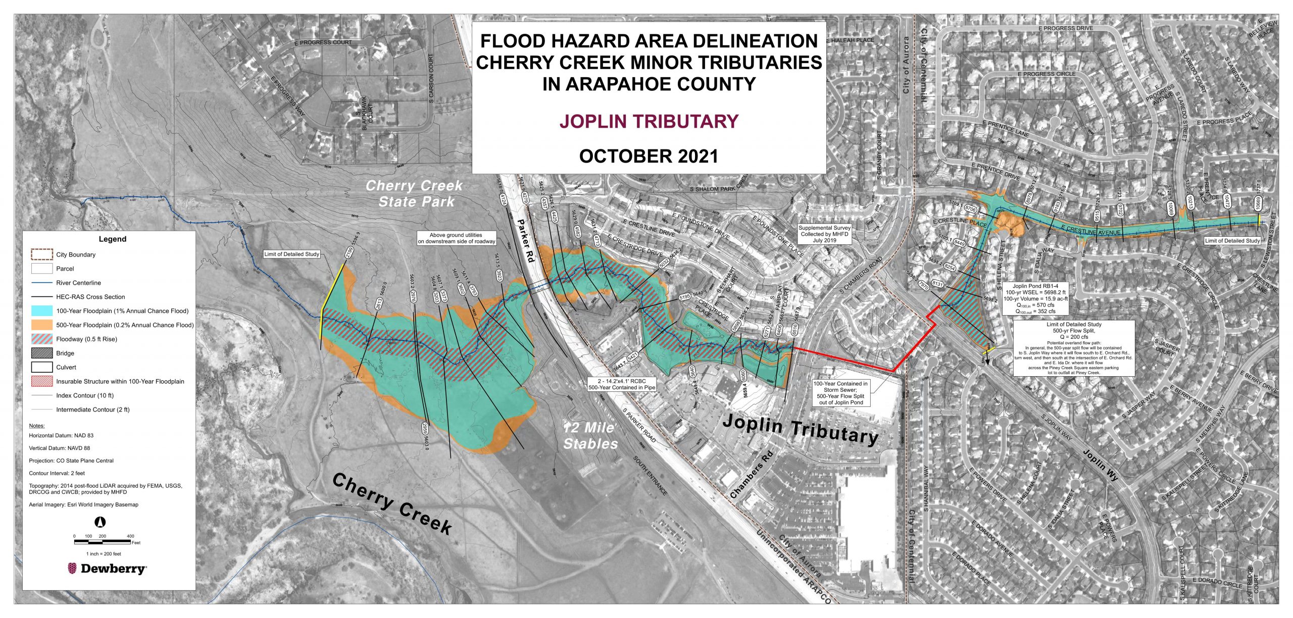
Joplin Tributary is a large tributary to Cherry Creek and is approximately 9,700 feet in length. The downstream half of the tributary runs through Cherry Creek State Park where it crosses multiple park trails, and the other half upstream of S. Parker Rd. conveys runoff from dense, mixed-use developments comprised of commercial big box stores and single- and multi-family developments in the Cities of Aurora and Centennial. The Joplin watershed combines a 360-acre area in the City of Aurora, a 217-acre area in the City of Centennial, and a 197-acre area in unincorporated Arapahoe County. SEMSWA serves the City of Centennial area and approximately 59 acres of unincorporated Arapahoe County.
FHAD
Joplin tributary is included in the FHAD. Due to the built-out nature of the basin, future land use hydrology was used for the FHAD and is considered equal to existing for Joplin Tributary. See the final FHAD report under the reports tab.
Alternatives
A lack of water quality within the Joplin Tributary basin was identified as part of the CCBWQA study. Therefore, the Status Quo or do nothing alternative and water quality considerations were evaluated for Joplin Tributary. The alternatives analysis for this tributary are as follows.
If you have comments on the recommended alternatives please email Katie Kerstiens: kkerstiens@mhfd.org.
Status Quo
The Status Quo alternative was evaluated to determine the cost associated with addressing minor erosional issues in the tributary and ongoing maintenance of the study reach (pond, culvert, and open channel).
Alternative 1 – Floodplain Preservation, Mitigation and Management
The floodplain preservation, mitigation and management alternative was not evaluated for Joplin Tributary because no adverse 100-year flooding conditions were found in the study reach.
Alternative 2 – Conveyance Improvements
No conveyance capacity deficiencies (up to and including the 100-year event) were found in the Joplin Tributary; therefore, the conveyance improvements alternative was not evaluated.
Considerations
The CCBWQA study identified potential benefits of retrofitting the existing detention pond, Pond RB1-Pond 4 to add water quality treatment within the Joplin Tributary basin.
The Pond RB1-Pond 4 drainage area, and water quality capture volume (WQCV) were analyzed in the CCBWQA study. The drainage area for the pond was determined to be 352 acres. The required WQCV was determined to be 5.8 acre-ft with a drain time of 40 hours. It was determined that an additional 3.8 acre-ft of storage capacity was required to be added to the pond to provide the required 5.8 acre-ft WQCV. The existing pond was retrofitted to provide that additional capacity. The conceptual design includes approximately 575 linear feet of retaining wall and a bottom slope of roughly 1%.
Recommended Alternative
To address minor erosional issues identified in the Joplin Tributary and the need for water quality within the basin, the Status Quo alternative along with retrofits adding water quality functionality to existing Pond RB1-Pond 4 is recommended. The addition of water quality functionality to existing Pond RB1-Pond 4 and stabilization of minor erosional issues will result in increased water quality discharged downstream into Cherry Creek.
Grove Ranch Tributary is the smallest watershed studied at 81 acres and less than a mile in basin length. The Grove Ranch watershed is served entirely by SEMSWA, with 77 acres located in the City of Centennial and 4 acres within unincorporated Arapahoe County.
FHAD
Grove Ranch tributary is not included in the FHAD since there is little to no open channel. Due to the built-out nature of this basin, future land use hydrology is considered equal to existing for Grove Ranch Tributary.
Valley Club Acres Tributary drains a tributary area of approximately 207 acres. The tributary is predominantly contained in storm sewer, with only 600 feet of open channel at the downstream confluence with Cherry Creek. The entire open channel reach is encumbered by the regulatory floodplain of Cherry Creek, as are approximately 1,500 feet of the upstream storm sewer. The Valley Club Acres Tributary area is composed of 110 acres in the City of Centennial, 91 acres in the City of Aurora, and 6 acres in unincorporated Arapahoe County. SEMSWA serves the areas in the City of Centennial and unincorporated Arapahoe County.
FHAD
Valley Club Acres Tributary is not included in the FHAD since there is little to no open channel. Due to the built-out nature of this basin, future land use hydrology is considered equal to existing for Valley Club Acres Tributary.
Alternatives
There are storm sewer capacity issues identified within the Valley Club Acres Tributary, and a lack of water quality within the basin. There is also an increase in flooding issues due to flows that transfer from the North Arapahoe Tributary basin into the Valley Club Acres Tributary basin due to insufficiently sized drainage infrastructure in the North Arapahoe Tributary basin. The alternatives and analyzed for this tributary are as follows.
If you have any comments on the recommended alternatives, please email Katie Kerstiens: kkerstiens@mhfd.org
Status Quo
Since there are extensive flooding issues in the Valley Club Acres Tributary during the 100-year event, the Status Quo alternative was not evaluated as substantial damage is anticipated to result from doing nothing in this reach.
Alternative 1 – Floodplain Preservation, Mitigation and Management
The floodplain preservation, mitigation and management alternative was not evaluated for Valley Club Acres Tributary because no FHAD was performed on the Valley Club Acres Tributary due to the small size of the contributing basin, and the extent of 100-year flooding is not known.
Alternative 2 – Conveyance Improvements
To reduce flood risk through the Valley Club Acres Tributary, storm sewer trunkline capacity improvements are required. The proposed conveyance improvements include upsizing undersized sections of the existing storm sewer trunkline, specifically:
· Replacing approximately 2,470 LF of the existing storm sewer trunkline from the location where the trunkline comes in from the east and meets the trunkline at S. Helena St. to the outfall at Cherry Creek (along the E. Caley Ave. alignment) with increased capacity, dual 10’x4’ RCBCs.
· Replacing approximately 550 LF of existing storm sewer trunkline along S. Lewiston Way from approximately 150 ft southeast of E. Weaver Pl. to 400 ft northwest of E. Weaver Pl. with increased capacity, 60-inch diameter RCP.
Considerations
The proposed dual 4’x10’ reinforced RCBCs were designed to follow the existing drainage pattern, which bucks grade and is generally not hydraulically efficient. In later stages of analysis and design, the community and engineer may choose to go with a different conveyance system that more optimally satisfies the site constraints. It is assumed that any future iteration of
Valley Club Acres Tributary conveyance system will be approximately the same cross-sectional area, and therefore roughly the same cost, as well as presented here.
During the baseline hydrology phase of this project, basin transfer from the North Arapahoe Tributary into the Valley Club Acres Tributary was identified. Therefore, it is important for the valley club acres stakeholders to understand that if drainage improvements in North Arapahoe lag, Valley Club Acres will still experience adverse flooding conditions as the proposed system was not designed to convey additional flow from the North Arapahoe basin transfer. The timing of improvements in the North Arapahoe and Valley Club Acres tributaries should be closely correlated. Should the North Arapahoe Tributary improvements proceed or coincide with those in Valley Club Acres, the Valley Club Acres community and engineer may elect to drain part of the Valley Club Acres watershed south into the North Arapahoe Basin as part of the water control plan.
Additionally, the CCBWQA study found benefit in locating a water quality pond in the Valley Club Acres Tributary. The proposed pond is located north of S. Lewiston Way on the Regis Jesuit High School (Regis) property directly west of the soccer fields. During the alternatives analysis, it was found that there is an existing detention pond (Private Pond #3 ) in this location that was constructed for Regis. Private Pond #3 was designed with a water quality capture volume (WQCV) to meet the needs of the Regis property (0.07 ac-ft) and has a detention volume of 0.09 ac-ft. The conceptual design of this pond includes the existing detention volume and WQCV required to treat and detain runoff from Regis, in addition to the proposed WQCV. The WQCV is 0.29 ac-ft and the total design volume of this pond is 0.67 ac-ft and has a depth of five feet. The bottom slope of the pond is approximately 2%.
Recommended Alternative
To reduce flood risk and address water quality concerns through the Valley Club Acres Tributary, Alternative 2 (storm sewer capacity improvements) and the addition of a water quality pond is recommended.
The recommended conveyance improvements, including upsizing undersized sections of the existing storm sewer trunk line with dual 10’x4’ RCBCs along S. Helena St. and E. Caley Ave. and a 60-inch RCP along S. Lewiston Way, will increase public safety by reducing flooding of roadways within the basin and properties within the Valley Club Acres community. The recommended water quality pond will improve water quality conveyed downstream into Cherry Creek.
It is advised that conveyance capacity improvements recommended in the North Arapahoe Tributary be constructed prior to or in conjunction with stormwater capacity improvements recommended in the Valley Club Acres Tributary. As noted previously, inter basin transfer from North Arapahoe into Valley Club Acres Tributary occurs as a result of undersized drainage infrastructure in the existing condition in the North Arapahoe Tributary. If improvements in the North Arapahoe Tributary basin are not implemented prior to or in conjunction with improvements recommended in the Valley Club Acres Tributary, flooding issues will persist in the Valley Club Acres Tributary as the Valley Club Acres Tributary improvements recommended herein and were not designed to handle additional flow from the North Arapahoe basin transfer.
The North Arapahoe watershed combines a 372-acre area, 206 acres of which are served by SEMSWA, 115 acres by the Town of Foxfield, and 51 acres by the City of Aurora. This watershed includes 141 acres in unincorporated Arapahoe County. Runoff from North Arapahoe watershed east of S. Buckley Rd. is conveyed in storm sewer and through a SEMSWA owned and maintained regional detention pond. Further downstream, runoff is conveyed under S. Parker Rd. before discharging directly to Cherry Creek. The uppermost part of this watershed is located south of E. Arapahoe Rd. in the Town of Foxfield.
FHAD
North Arapahoe Tributary is not included in the FHAD since there is little to no open channel. Due to the built-out nature of this basin, future land use hydrology is considered equal to existing for North Arapahoe Tributary.
Alternatives
Storm sewer capacity issues were identified within the North Arapahoe Tributary. The alternatives analyzed for this tributary are as follows.
If you have any comments on the recommended alternatives, please email Katie Kerstiens: kkerstiens@mhfd.org
Status Quo
Since there are extensive flooding along N. Arapahoe Rd. (an arterial roadway) during the 100-year event, the Status Quo alternative was not evaluated as substantial public safety concern is anticipated to result from doing nothing in this reach.
Alternative 1 – Floodplain Preservation, Mitigation and Management
The floodplain preservation, mitigation and management alternative was not evaluated for the North Arapahoe Tributary because no FHAD was performed on the North Arapahoe Tributary (the extent of 100-year flooding is not known), and it is not feasible to decommission an arterial roadway to turn it into a drainage easement.
Alternative 2 – Conveyance Improvements
To reduce flood risk through the North Arapahoe Tributary, storm sewer trunkline capacity improvements are required. The proposed conveyance improvements include upsizing undersized sections of the existing storm sewer trunkline within E. Arapahoe Rd., specifically:
· Replacing approximately 1,350 LF of the existing storm sewer trunkline from S. Waco St. to Our Lady of Loreto Access with 36” RCP.
· Replacing approximately 2,750 LF of existing storm sewer trunkline from Our Lady of Loreto Access to S. Buckley Rd. with 54” RCP.
· Replacing approximately 2,675 LF of existing storm sewer trunkline from S. Buckley Rd. to NE Parker Rd./E. Arapahoe Infield with 60” RCP.
· Adding approximately 635 LF of 48” storm sewer trunkline from Parker Rd./E. Arapahoe Rd. infield to NW Parker Rd./E. Arapahoe Rd. infield.
· Replacing approximately 2,475 LF of existing storm sewer trunkline from NW Parker Rd./E. Arapahoe Rd. infield to the outfall at Cherry Creek with 72” RCP.
Considerations
The CCBWQA study identified a benefit of providing water quality in the North Arapahoe Tributary basin. The potential water quality pond location, drainage area, and water quality capture volume (WQCV) were analyzed in the CCBWQA study. The proposed pond is located just southwest of the Our Lady of Loreto Church (off of E. Arapahoe Rd. and S. Waco St.), on private property zoned as a single-family parcel (Parcel ID 2073-28-1-00-002). The drainage area for the pond is 62 acres. The required WQCV was determined to be 0.73 ac-ft with a drain time of 40 hours. The conceptual design of the pond has 1 ac-ft volume and is 4 ft deep. The bottom slope of the pond is roughly 1%.
Recommended Alternative
To reduce flood risk and address water quality concerns through the North Arapahoe Tributary, Alternative 2 (storm sewer capacity improvements) and the addition of a water quality pond is recommended.
The recommended storm sewer improvements, including upsizing undersized sections of the existing storm sewer trunk line within E. Arapahoe Rd. with 36” to 72” RCP will increase public safety by reducing flooding of Arapahoe Road and basin transfer into the Valley Club Acres Tributary by conveying runoff within the storm sewer trunkline in Arapahoe Rd. The recommended water quality pond will improve water quality conveyed downstream into Cherry Creek for the CCBWQA.
It is advised that conveyance capacity improvements recommended in the North Arapahoe Tributary be constructed prior to or in conjunction with stormwater capacity improvements recommended in the Valley Club Acres Tributary.
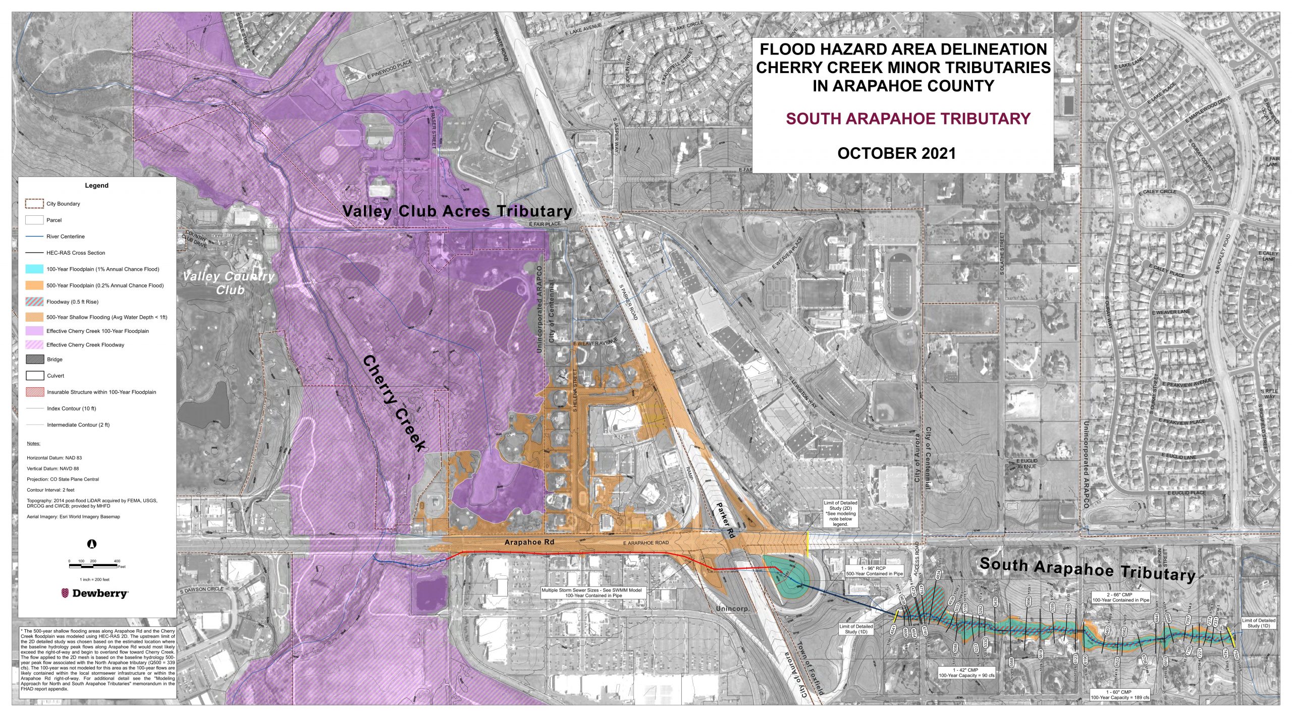
The South Arapahoe watershed combines a 317-acre area in the Town of Foxfield, a 70-acre area in the City of Aurora, a 5-acre area in unincorporated Arapahoe County, and a 4-acre area in the City of Centennial. SEMSWA provides service to the City of Centennial area and 3 acres of unincorporated Arapahoe County. A small area of 1.5 acres is located in unincorporated Arapahoe County but is not currently served by SEMWA.
FHAD
South Arapahoe Tributary is included in the FHAD. Due to the built-out nature of this basin, future land use hydrology is considered equal to existing for South Arapahoe Tributary.
Alternatives
There are culvert capacity issues identified within the South Arapahoe Tributary at S. Pitkin St. and S. Norfolk Ct. The alternatives analyzed for this tributary are as follows.
Status Quo
Since there are roadway overtopping and inundation at S. Pitkin St. and S. Norfolk Ct. during the 100-year event, the Status Quo alternative was not evaluated as substantial public safety and emergency evacuation route concerns are anticipated to result from doing nothing in this reach.
Alternative 1 – Floodplain Preservation, Mitigation and Management
The floodplain preservation, mitigation and management alternative was not evaluated for the South Arapahoe Tributary because the area of concern was limited to the S Pitkin St. and S. Norfolk Ct. culvert crossings – no adverse impact to surrounding homes was identified.
Alternative 2 – Conveyance Improvements
To reduce roadway inundation risk within the South Arapahoe Tributary, culvert capacity improvements are required. The proposed culvert improvements include upsizing the undersized culverts, specifically:
· Replacing the existing 48” CMP at S. Norfolk Ct. with dual 48” RCPs and adding energy dissipation downstream of the improved crossing to reduce outlet hydraulics to those permissible in the receiving stream.
· Replacing the existing 60” CMP at S. Pitkin St. with dual 60” RCPs and adding energy dissipation downstream of the improved crossing to reduce outlet hydraulics to those permissible in the receiving stream.
Considerations
No additional considerations were paid to improvements in South Arapahoe Tributary.
Recommended Alternative
To reduce flood risk and address public safety concerns in the South Arapahoe Tributary, Alternative 2 (culvert capacity improvements) is recommended. The recommended conveyance improvements include upsizing the existing culvert at S. Norfolk Ct. from a 48” CMP to dual 48” RCPs, and at S. Pitkin St. from a 60” CMP to dual 60” RCPs. Additionally, energy dissipation structures are recommended downstream of both culvert crossings to reduce outlet hydraulics to those permissible in the receiving channel.
The improved culvert crossings will reduce public safety concerns by providing an unobstructed emergency access route for areas of the community that were previously cut off during the 100-year event (see FHAD). Additionally, the improved culvert crossings with energy dissipation will reduce the erosion potential downstream of the culverts, and therefore improve water quality conveyed downstream into Cherry Creek.
Public outreach for South Arapahoe Tributary will be coordinated through the Town of Foxfield in early 2024.
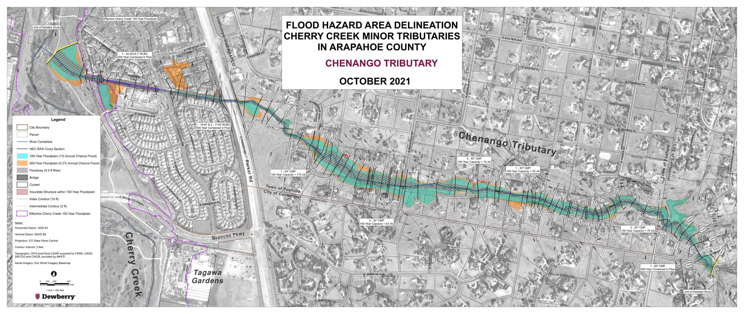
Chenango Tributary is the largest watershed and conveys runoff from 920 acres to Cherry Creek through the Cherry Creek Valley Ecological Park from the Chenango Development, which is a single-family large lot rural development that is fully built out. The Chenango watershed combines a 450-acre area in the City of Centennial, a 376-acre area in the Town of Foxfield, and a 90-acre area in unincorporated Arapahoe County. SEMSWA serves the areas in the City of Centennial and unincorporated Arapahoe County.
FHAD
Chenango Tributary is included in the FHAD. Due to the built-out nature of this basin, future land use hydrology is considered equal to existing for Chenango Tributary. The flood hazard area delineation (FHAD) identified four insurable structures inundated by the upper portion of the Chenango Tributary 100-year floodplain. The FHAD also identified inundation of approximately 2,850 LF of E. Hinsdale Way and 170 LF of S. Yampa St. during the 100-year event, which poses a public safety concern. Both the insurable structures and roadway inundation is caused by inadequate open channel and culvert capacity throughout the reach. Additionally, there are no water quality features on Chenango Tributary. The alternatives analyze for this tributary are as follows.
Alternatives
The Status Quo, Alternative 1, and Alternative 2 were evaluated for improvements in the basin.
Status Quo
Since there are four homes and local roadways identified in the 100-year floodplain, the Status Quo alternative was not evaluated as substantial damage and public safety concern are anticipated to result from doing nothing in this reach.
Alternative 1 – Floodplain Preservation, Mitigation and Management
To preserve the existing Chenango Tributary floodplain in the reach of interest, a permanent drainage easement 32 acres in size is required to contain the 100-year floodplain. Additionally, approximately 3,020 LF of E. Hinsdale Way and S. Yampa St. will need to be relocated, 11 culverts crossing beneath local roadways and access roads will need to be repaired, and the four homes identified as being inundated by the 100-year floodplain are required to be purchased and demolished.
Alternative 2 – Conveyance Improvements
To reduce flood and public safety concerns through the Chenango Tributary study reach, conveyance capacity improvements are required. The proposed conveyance improvements include a high functioning low maintenance process channel, in combination with local roadway and access road culvert crossing improvements designed to convey the 100-year event.
The proposed channel has a stable slope of 0.8%, 1.5 feet of freeboard in the channel between the 100-year water surface elevation and the surrounding terrain, and 16 three-foot grade control structures required to maintain the slope. The culverts are designed to convey the 100-year event with one foot of freeboard and satisfy the maximum head water to depth criteria of 1.5. All 16 culverts will require energy dissipation at their outlets to reduce outlet velocities and shear stresses to those permissible in the channel. It is assumed that the grade control structures can be placed such that they function as both grade control and energy dissipation downstream of the culverts.
Considerations
As previously mentioned, the FHAD phase of the study identified insufficient channel and culvert capacity throughout the Chenango Tributary reach upstream of Parker Rd. A peak-shaving detention basin feasibility analysis was performed to assess the available storage capacity on an undeveloped parcel that sits at the confluence of several tributaries in the watershed and evaluated the associated benefit of downstream peak flow reduction. The results indicated that, even with significant excavation from the parcel to increase storage capacity, little reduction in downstream peak flow resulted. Therefore, the detention alternative was not progressed further.
Several parcels within the Chenango Tributary have two access points, one of which is located within the footprint of the proposed improvements. In such cases, it was assumed that the access point that is not located within the proposed improvements will function as the parcel ‘s primary access point. Therefore, it was assumed that Mile High Flood District will not pay for improvements required to maintain secondary access to the parcel(s). However, design in culvert sizing calculations for the secondary accesses were provided for informational purposes only.
Additionally, the CCBWQA study identified the benefit of providing water quality in the Chenango Tributary. The water quality pond location, drainage area, and water quality capture volume (WQCV) were analyzed in the CCBWQA study. The proposed online pond is located on Chenango Tributary upstream of S. Parker Rd. The portion of the creek is located on private property; however, the parcel is zoned as vacant and unplatted. The drainage area for this pond is 775 acres. The WQCV was calculated to be 8.9 ac-ft with a drain time of 40 hours. The conceptual design of the pond has 9.4 ac-ft volume and is 6 feet deep. The bottom slope of the pond is roughly 1%.
Recommended Alternative
To reduce flood risk and address water quality concerns in the Chenango Tributary, Alternative 2 (open channel and culvert conveyance capacity improvements) and the addition of a water quality pond is recommended.
The improved channel in culverts will increase public safety by removing 4 insurable structures, as well as approximately 2,850 LF of E. Hinsdale Way and 170 LF of S. Yampa St. (Local roadways) from the 100-year floodplain. Additionally, the improved culvert crossings will reduce public safety concerns by providing an unobstructed emergency access route for homes within the community that were previously cut off during the 100-year event (see FHAD). The recommended water quality pond will improve the water quality of the flow conveyed downstream into Cherry Creek for the CCBWQA. Additionally, the recommended high functioning low maintenance process channel will increase the environmental function of the reach by providing a more natural stream environment and reconnecting the channel to its natural plan inform.
Public outreach for Chenango Tributary will be coordinated through the Town of Foxfield in early 2024.
The Tagawa watershed is entirely contained in the City of Centennial, which is served by SEMSWA. The tributary outfalls directly to Cherry Creek and is located to the south of Chenango Tributary and north of Kragelund Tributary.
FHAD
Tagawa Tributary is not included in the FHAD since there is little to no open channel. Due to the built-out nature of this basin, future land use hydrology is considered equal to existing for Tagawa Tributary.
Alternatives
The Tagawa Tributary basin is one of the smaller basins in the study. The only potential issues found within the basin were the presence of erosion in a small reach just upstream of Parker Road, and the lack of water quality within the basin.
Status Quo
The Status Quo alternative evaluated the cost of addressing routine maintenance requirements associated with ongoing minor erosional issues that were identified in Tagawa Tributary just upstream of Parker Road (primarily adjacent to Parker road and within 7631 S. Pagosa Ct. parcel).
Alternative 1 – Floodplain Preservation, Mitigation and Management
The Floodplain Preservation, Mitigation and Management alternative was not evaluated for Tagawa Tributary because no FHAD was performed on this reach, and no adverse impact to surrounding homes were identified.
Alternative 2 – Conveyance Improvements
No FHAD was developed for Tagawa Tributary and no existing conveyance deficiencies were observed; therefore, the conveyance improvements alternative was not evaluated.
Considerations
No additional considerations were paid to improvements in Tagawa Tributary.
Recommended Alternative
To address minor erosional issues identified in the Tagawa Tributary, the Status Quo alternative is recommended. The Status Quo alternative was evaluated to determine the cost associated with addressing minor erosional issues in the tributary and ongoing maintenance of the study reach. By addressing erosional issues within the tributary, the amount of sediment transported downstream into Cherry Creek will be reduced, increasing water quality.
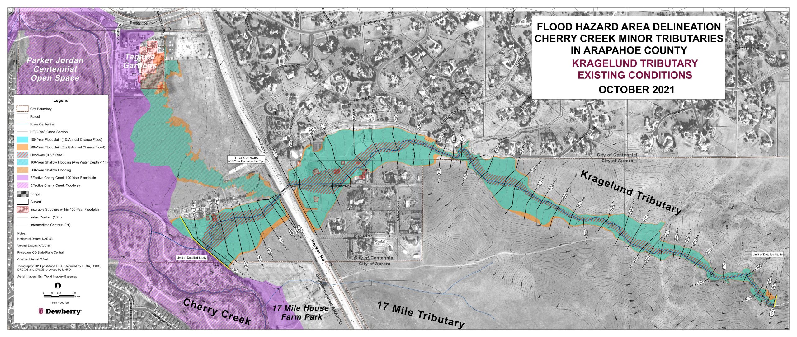
Kragelund Tributary conveys runoff from approximately 611 acres of mostly undeveloped land and provides the best opportunity for floodplain preservation and was previously referred to as South Unnamed Tributary. Future development is anticipated from the headwaters near E-470 and King’s Point, through privately owned property currently managed by the Vermillion Creek Metropolitan District, to the confluence with Cherry Creek within the PJCOS. The Kragelund watershed combines a 343-acre area in the City of Aurora, a 259 acre-area in the City of Centennial, and 7-acre area in unincorporated Arapahoe County. SEMSWA serves the areas in the City of Centennial and unincorporated Arapahoe County.
FHAD
Kragelund Tributary is included in the FHAD. Kragelund Tributary is largely undeveloped at the time of this study and therefore existing conditions land use and hydrology were used. Upstream development will be required to discharge at historic rates once developed.
The FHAD identified 10 insurable structures (nine residential and one commercial) in the Kragelund Tributary 100-year floodplain. The FHAD also identified that approximately 630 LF of E. Mineral Pl. (a local roadway) is inundated during the 100-year event which poses a public safety concern. Both the insurable structures and roadway inundation is caused by inadequate open channel capacity throughout the reach. Additionally, upstream development is anticipated to increase the frequency of events in the reach and effect the hydraulic regime of the reach, creating instability in the system. The alternatives analyze for this tributary are as follows.
Alternatives
Alternative 1 and Alternative 2 were evaluated for improvements in the basin.
Status Quo
Since there are ten insurable structures and a local roadway identified in the 100-year floodplain, the Status Quo alternative was not evaluated as substantial damage and public safety concern is anticipated to result from doing nothing in this reach.
Alternative 1 – Floodplain Preservation, Mitigation and Management
To preserve the existing Kragelund Tributary floodplain in the reach of interest, a permanent drainage easement 70 acres in size is required to contain the 100-year floodplain. Additionally, approximately 650 LF of E. Mineral Pl. will need to be relocated, and the ten insurable structures on six parcels as being inundated by the 100-year floodplain are required to be purchased and demolished.
If you have comments on the recommended alternatives please email Katie Kerstiens: kkerstiens@mhfd.org.
Alternative 2 – Conveyance Improvements
To reduce flood and public safety risk through the Kragelund Tributary study reach, conveyance capacity improvements are required. The proposed conveyance improvements include a high functioning low maintenance process channel, in combination with one property access loop and two trail culvert crossing improvements designed to convey the 100-year event.
The proposed channel has a stable slope of 1%, 1.5 feet of freeboard in the channel between the 100-year water surface elevation and the surrounding terrain, and 9 three-foot grade control structures to maintain the slope. The culverts are designed to convey the 100-year event with one foot of freeboard and satisfy the maximum head water to depth criteria of 1.5. Culvert outlet velocities are approximately equal to those permissible in the channel; therefore, no energy dissipation is anticipated to be required downstream of the new culverts.
Considerations
Part of a separately funded project performed during the King’s Point Development Review, Dewberry assessed potential benefits of over detaining flows being discharged from the King’s Point Development using a regional detention facility. This analysis was performed to identify the feasibility and required size of a regional detention facility that would result in immediate reduction in flood risk in the study reach and be constructed prior to planned implementation of the recommended alternative. The results of that analysis indicated that an infeasibly large detention facility would be required due to very limited capacity in the existing low-flow channel and frequent (between 2- and 10-year event) spills into a secondary channel through insurable structures.
Recommended Alternative
To reduce flood risk in the Kragelund Tributary, Alternative 2 (open channel conveyance capacity improvements) is recommended. Recommended conveyance improvements include a high functioning low maintenance process channel, in combination with 9 three-foot grade control structures, one maintenance access trail and two trail culvert crossing improvements within open space areas designed to convey the 100-year event.
The conveyance capacity improvements will increase public safety by removing ten insurable structures, as well as approximately 630 LF of E. Mineral Pl. from the 100-year floodplain. The recommended high functioning low maintenance process channel will reduce the potential for upstream development-induced erosion within the reach, improving water quality conveyed downstream into Cherry Creek. Additionally, the recommended high functioning low maintenance process channel will increase the environmental function of the reach by providing a more natural stream environment and reconnecting the channel to its natural plan and form.
17 Mile watershed combines a 97-acre area in the City of Aurora, a 16 acre-area in the City of Centennial, and 15-acre area in unincorporated Arapahoe County. SEMSWA serves the areas in the City of Centennial and unincorporated Arapahoe County. It is the most southern tributary of this study and is located just north of the Arapahoe County / Douglas County border. This poorly defined tributary drains approximately 145 acres, and is bisected by S. Parker Rd. This watershed is also largely undeveloped upstream of S. Parker Rd. but is expected to be fully built-out following development of King’s Point.
FHAD
17 Mile Tributary is not included in the FHAD since there is little to no open channel. 17 Mile Tributary is largely undeveloped at the time of this study and therefore existing conditions land use and hydrology were used. Upstream development will be required to discharge at historic rates once developed.
Alternatives
The 17-Mile Tributary basin is a smaller basin that is mostly undeveloped. However, proposed upstream development is anticipated to increase the frequency of events and effect the hydraulic regime of the reach, creating instability in the system. The alternatives analyzed for this tributary are as follows.
If you have any comments on the recommended alternatives, please email Katie Kerstiens: kkerstiens@mhfd.org
Status Quo
A FHAD was not completed for the 17 Mile Tributary. However, no insurable structures are anticipated to be inundated during the 100-year event – only channel instability and erosion issues are anticipated. As such, the Status Quo alternative was evaluated to determine the costs associated with addressing erosion issues in the tributary and ongoing maintenance of the study reach.
Alternative 1 – Floodplain Preservation, Mitigation and Management
To preserve the existing 17 Mile Tributary floodplain in the reach of interest, a permanent drainage easement 7 acres in size is anticipated to be required to contain the 100-year floodplain through the 17 Mile House property.
Alternative 2 – Conveyance Improvements
To reduce flood risk and potential erosional issues in the 17 Mile Tributary study reach, conveyance improvements are required. The proposed conveyance improvements include a high functioning low maintenance process channel, in combination with one access road culvert crossing designed to convey the 100-year event.
The proposed channel has a stable slope of 1.1%, 1.5 feet of freeboard in the channel between the 100-year water surface elevation and the surrounding terrain, and8 tow-foot grade control structures required to maintain the slope. The culvert is designed to convey the 100-year event with one foot of freeboard and satisfy the maximum head water to depth criteria of 1.5. The 100-year culvert outlet velocity is greater than that permissible in the channel; therefore, the culvert will require energy dissipation at its outlet to reduce outlet velocities and shear stresses to those permissible in the channel. It is assumed that a grade control structure can be placed such that it functions as both grade control and energy dissipation downstream of the culvert.
Considerations
The 17 Mile House, located directly adjacent to the 17 Mile Tributary just downstream of Parker Road, as well as the property that the 17 Mile House is situated upon is identified as having historic value and is located in designated easements. As such, coordination with the conservation easement grantees is anticipated required in the future to obtain permits to perform the work. Access to 17 Mile House is in process of being revised as of the date of this publication as a result of the King’s Point Development. The next phase of work at the 17 Mile House may need to consider the revised property access route.
Recommended Alternative
To reduce flood risk in the 17 Mile Tributary, Alternative 2 (open channel conveyance capacity improvements) is recommended. The recommended conveyance improvements include a high functioning low maintenance process channel, in combination with 8 two-foot grade control structures, and one access road culvert crossing designed to convey the 100-year event.
The conveyance capacity improvements will increase public safety by reducing the 100-year floodplain inundation area within a historical parcel and will benefit the community by containing the 100-year floodplain with a reduced footprint. The recommended high functioning low maintenance process channel will reduce the potential for upstream development-induced erosion within the reach, improving water quality conveyed downstream into Cherry Creek. Additionally, the recommended high functioning low maintenance process channel will increase the environmental function of the reach by providing a more natural stream environment and reconnecting the channel to its natural plan and form. Coordination with the conservation easement grantees is anticipated to in the future to obtain permits from the work.
This website uses cookies so that we can provide you with the best user experience possible. Cookie information is stored in your browser and performs functions such as recognising you when you return to our website and helping our team to understand which sections of the website you find most interesting and useful.
Strictly Necessary Cookies
Strictly Necessary Cookie should be enabled at all times so that we can save your preferences for cookie settings.
If you disable this cookie, we will not be able to save your preferences. This means that every time you visit this website you will need to enable or disable cookies again.
3rd Party Cookies
This website uses Google Analytics to collect anonymous information such as the number of visitors to the site, and the most popular pages.
Keeping this cookie enabled helps us to improve our website.
Please enable Strictly Necessary Cookies first so that we can save your preferences!